GEOGRAPHY

urenque has about 600 inhabitants and is located between twos areas called «Ségala» and «Lévezou». Two rivers (Viaur and Tarn) respectively run in north and south valleys.
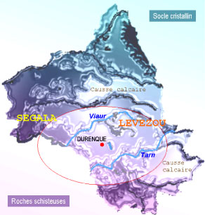 Since the uprising of the «Massif Central», the huge geological shift has created a crystalline plinth in the north, and a zone of primary slate rocks in the south.
Durenque sits at about 720m above sea level and «Mont Lagast *» (928m) overhangs the village.
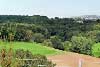
The surrounding country is covered by a green undulated surface broken by small valleys where water mills are frequent. «Bories» (Hamlets or little farms) often sit on «Puechs» (Hills).
The meadows are edged with hawthorn, holly and mulberry trees forming a hedged farmland witch is intersected by woods. These little forests are generally composed of beeches and oaks. Plantations of conifers fit into that natural surroundings.
«Lévezou» has some great lakes which accentuate the beauty of the landscapes.
* In the 18th century, a geodesic signal was established on the top of Mont Lagast. This landmark point contributed to the elaboration of the meridian line of France by the French geographer Loiseleur Deslongchamps.
CLIMATE
The country offers a temperate mountain climate.
Mount Lagast protects Durenque from the cold winds blowing from the North, so the village takes advantage to the generous sunshine of the South mountainside.
Frost is frequent in winter with some light snow. Spring is pleasant with warm, fresh air and summers are hot. Autumn comes late and is generally very mild.
The «Vent dAutan» is a strong dry wind. It comes from the Southeast and sweeps the country, usually bringing the rain with it.
The altitude and lack of large urban development means the air is clean, giving a healthy atmosphere and climate.
TOURISM
Visitors can enjoy rural calm and a very peaceful environment.
Rural paths for hikers cross the wood «Chantecoucou» and the forest of «Mont Lagast». Many other country walks also offer adventure tours (Some walking maps are available in town hall).
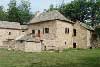
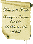
 The lower part of the village (Roupeyrac) has a large fishing pond and a water mill, which was once the house of poet François Fabié. To honour the writer this building has been entirely restored and is now a museum. The lower part of the village (Roupeyrac) has a large fishing pond and a water mill, which was once the house of poet François Fabié. To honour the writer this building has been entirely restored and is now a museum.
Visits from May till October (closed on Tuesday) adult: 4 child: 3 group: 3.
There is a public campsite with tennis courts adjacent to the pond.
CAMPSITE PRICE LIST:
Area : 3.50 € - Adult : 1.20 € - Child : 0.50 €
Car-camping car : 0.70 € - Connection : 1.50 € - Shower : 0.70 €
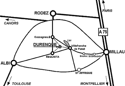
The Villefranche de Panat lake lies 8klms from the village and has swimming beaches, water activities, bars, restaurants and campsites.
Brousse-le-Château, Najac, Conques, La Couvertoirade, Belcastel, Rouergue and the Millau Viaduct are some of the many sites of interest in the department of Aveyron.
Durenque is surrounded by three main towns: Rodez, Albi, Millau, each offering a variety of tourist excursions and excellent restaurants. The nearest airport is at Rodez.
TOURIST INFORMATION
Durenque town council: 05.65.46.58.03
e-mail: mairie-durenque@wanadoo.fr
Durenque tourist office: 05.65.78.18.85
e-mail: info@moulinderoupeyrac.fr
Réquista tourist office: 05.65.46.11.79
e-mail: info.requista@roquefort.com
|
 Useful websites:
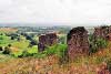
 ...Durenque seen from Mont Lagast